

Posted in News Events, Photographs, Updates, tagged Aground, Philippines, Salvage, Sulu Sea, Tubbataha, Tubbataha Reefs, USS Guardian on March 27, 2013| Leave a Comment »
Posted in News Events, Photographs, Uncategorized, Updates, tagged Aground, Philippines, Tubbataha, Tubbataha Reefs, USS Guardian on March 14, 2013| Leave a Comment »
Posted in News Events, Photographs, Updates, tagged Aground, Chainsaw, Philippines, Tubbataha, Tubbataha Reefs, USS Guardian, Warship on March 10, 2013| Leave a Comment »
Here’s are some photo updates from what’s now left of the USS Guardian at Tubbataha Reefs. The Salvage crews have been making good progress with the chainsaw’s.
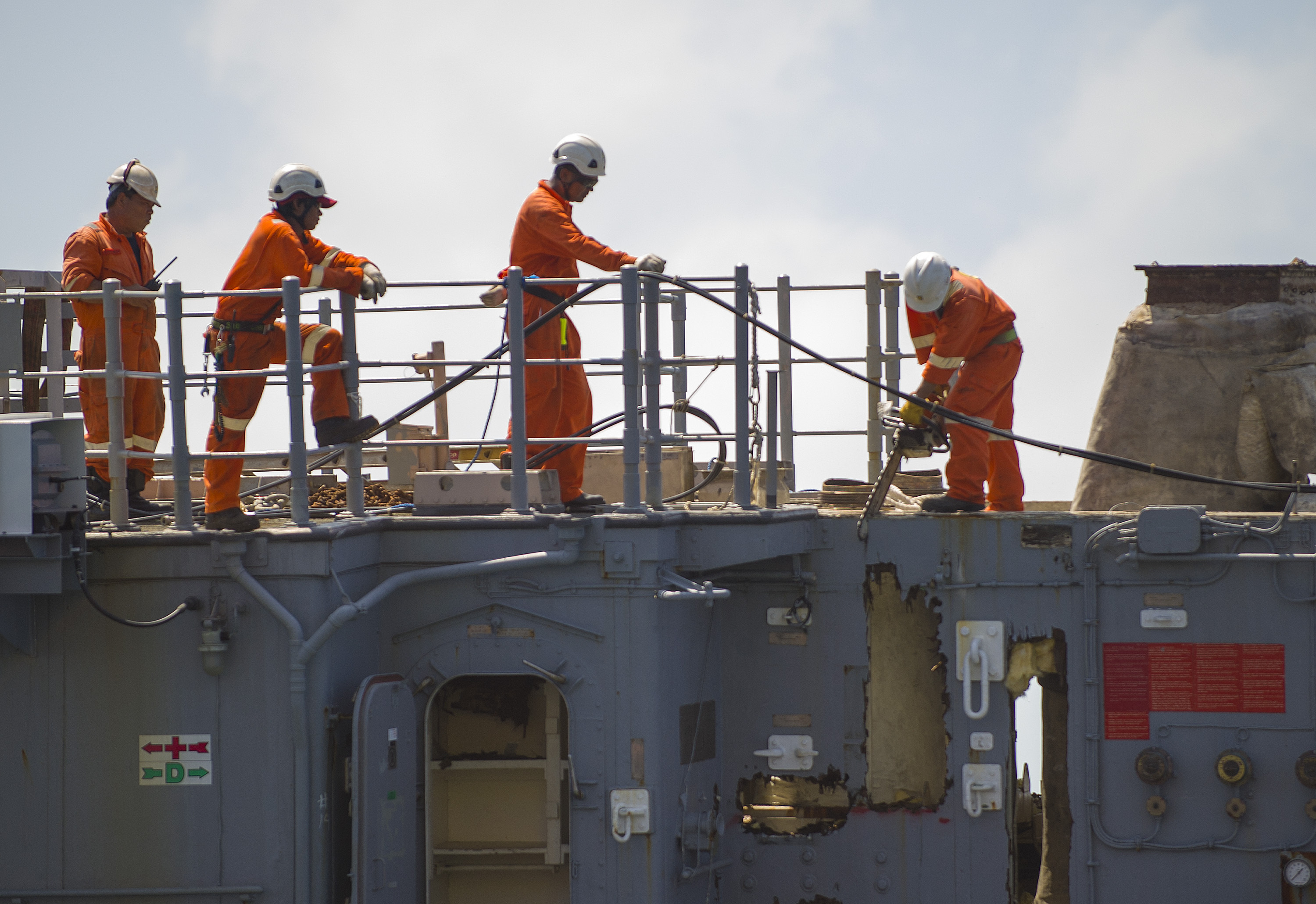

To date they have removed all of the ship superstructure the bridge deck and most of the main deck level !
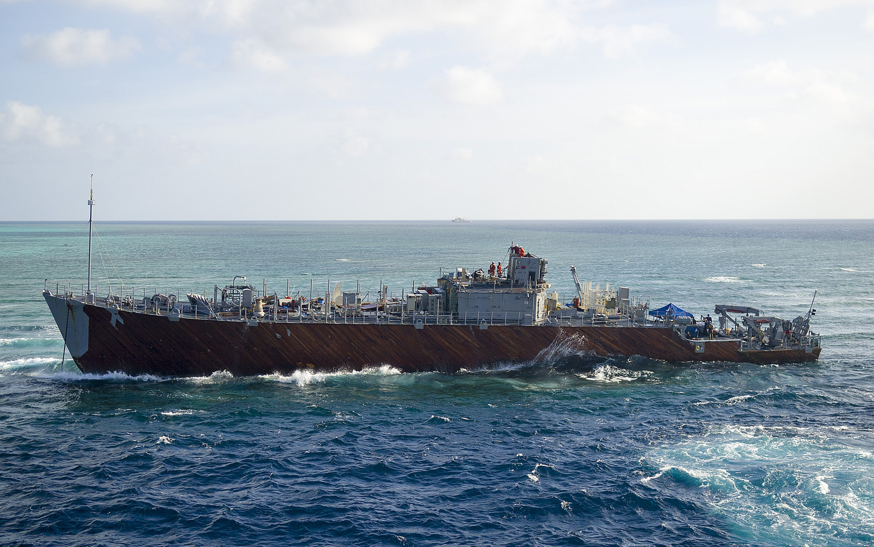
The USS Guardian Bridge Deck, where the on watch crew set the fateful course for the vessel that led her to founder on the Tubbataha Reef is now seen on the deck of the Crane Vessel, the Jascon 25.

It’s from one of those consoles that the on watch crew declined to heed the radio warnings from the Park Rangers, that the ship had entered the restricted reef area, and famously reportedly radioed back to “bring [their] complaint to the U.S. Embassy.” A sad tale and a sad outcome for the USS Guardian.
Whilst the ship was being cut up, the US Navy held a USS Guardian Valedictory at the ship base in Japan. The following are extracts from the ceremony.
.
Vice Adm. Tom Copeman , Commander Naval Surface Force, U.S. Pacific Fleet fittingly remembers USS Guardian, now being scrapped.
“During times of war and while operating in international exercises for nearly a quarter of a century, the crew and ship remained at the highest levels of readiness, serving our nation well,” noted Admiral Copeman. He continued:
“A significant moment during a ship commissioning ceremony occurs when there is a call to ‘bring this ship to life,’ and the crew sprints from their positions pierside, across the brow and into the ship itself, effectively adding life to what was once cold iron.
Equally momentous for a ship is when she is decommissioned, stricken from the fleet and returned to cold iron; the crew and former crewmembers left with their memories and reminders of serving our nation and multiple missions on an endless sea.
.
Well in this case it is wet wood not cold iron as she is a minesweeper, but we get the point.
The Salvage crew have made good progress and they will be keen to complete the job as quickly as posible before bad weather like this sweeps in again.
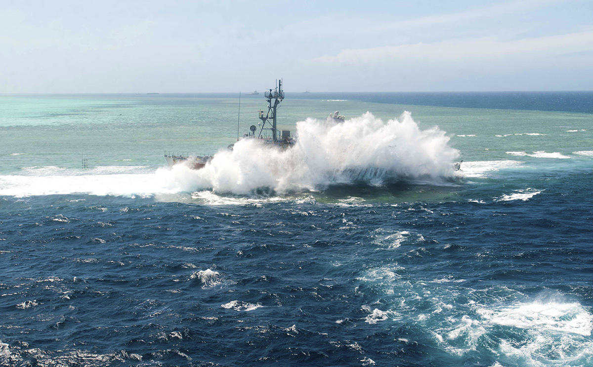
With the superstructure and bridge deck gone the ship structure will be weak and any large swell and waves like above could break up the vessel hull and scatter the contents around the reef. I’m sure they will be “buzzing” to get things completed, and get the job done.
Posted in News Events, Photographs, Uncategorized, Updates, Video, tagged Aground, Sulu, Tubbataha, Tubbataha Reefs, USS Guardian on January 24, 2013| Leave a Comment »
Source Wikipedia.
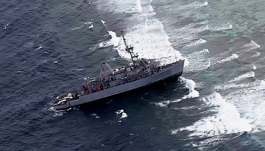
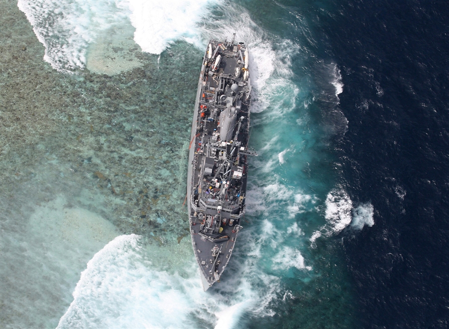
On 17 January 2013 following a port call and fuel stop in Subic, Guardian proceeded across the Sulu Sea and entered the Tubbataha Reefs Natural Park. After appearing on Park radar, at approximately 0400 hours local time Guardian was radioed a warning by park officials that the vessel had entered a restricted area. Park officials claim their lawful warning was met with disregard by Guardian, which radioed back to “bring [their] complaint to the US Embassy.” Shortly thereafter, the captain of the USS Guardian ran his vessel aground on Tubbataha Reef, about 130 kilometres (70 nmi) south east of Palawan in the Philippines. At the time of the accident the ship was travelling from Subic Bay in the Philippines to another port. The extent of any damage to the reef is unknown, but there is no evidence that fuel oil is leaking; damage to the reef has been estimated at 10 meters by the World Wide Fund for Nature Philippines. The U.S. Navy evacuated all 79 crew members from the minesweeper to the USNS Bowditch and MV C Champion on 18 January. On January 19, an assessment team was deployed would plan and execute the vessel’s extraction. On January 20, 2013, the Navy Times reported the ship is taking on water in multiple places and is experiencing a slight list to port.
The comments in the article of the Park Rangers on the Reef calling the USS Guardian by Radio reminded me very much of the following………Click the picture below to play the Video……
.

.
Posted in News Events, Uncategorized, tagged Aground, costa concordia, costa crociere, Costa Cruises, Giglio, grounded, Hydrographic, italian charts, la notte di san lorenzo, Lloyd's, rocks, UKHO on January 19, 2012| 2 Comments »
Exclusive: Costa Concordia in previous close call – FREE CONTENT
Wednesday 18 January 2012, 00:30
by Wally Mandryk and David Osler
Data provided by Lloyd’s List Intelligence
But cruise line insists Friday’s deviation from route was unauthorised
EXCLUSIVE analysis of Lloyd’s List Intelligence tracking data shows that Costa Concordia sailed within 230 m of the coast of Giglio Island on a previous voyage, slightly closer to the shore than where it subsequently hit rocks on Friday.
The cruiseship, which capsized off the Italian coast, had previously changed course to get closer to Giglio on the night of August 14 last year — for La Notte di San Lorenzo, the night of the shooting stars, owners Costa Cruises have said.
Speaking at a news conference on Monday, the company’s chief executive officer, Pier Luigi Foschi, stressed that the decision was taken under the authorisation of the local martime authority and the permission of Costa, after the route was reviewed. He also claimed that the vessel was never closer than 500 metres from the coast at any pont in the voyage.
The route taken on January 13, however, was described by Costa Cruises as a deviation from the pre-planned route to make a manoeuvre that was “unauthorised, unapproved and unknown to Costa”.
Both routes passed within a few hundred metres of each other and the tracking data, obtained through Lloyd’s List Intelligence proprietary land based AIS receivers, proves that the vessel would have been less than 200 m away from the point of collision when it took the previously authorised route. The route also took the vessel far closer than the 500 metres claimed by Costa Crociere.
Meanwhile, the UK Hydrographic Office has issued a statement, declining to comment on whether Costa Concordia was using one of its charts.
However, UKHO has confirmed that Italian charts of the area around Giglio are available on a larger scale than the 1:300,000 charts it issues.
Although this might seem to be a technical matter, the master of the vessel, who is under investigation for suspected manslaughter, has blamed the casualty on the cruiseship hitting an uncharted rock. This could make charts critical to the case for the defence, should the master face a criminal prosecution.
No rock is shown on the UKHO chart at the position in which Costa Concordia sank.
The UKHO said: “This is a regrettable incident where life was lost and a full investigation will be undertaken by the Italian maritime authorities. A report will be published following that investigation.
“The UKHO expects that the report will contain information about the chart or charts used by the vessel at the time of the incident, and also expects the report to describe what features were present on the charts being used.
“The UKHO does not wish to prejudice the investigation, and so will not enter into speculation about which chart may have been in use by the vessel at the time of the incident.
“The UKHO’s most detailed paper chart of the area in which the vessel grounded is Chart 1999 at a scale of 1:300 000, which is up to date for all relevant information known to the UKHO. It should be noted that this small scale chart is considered to be unsuitable for close inshore navigation.
“Larger scale paper charts, produced by the Italian hydrographic service, are available. The official digital charts are Italian with larger scales available.”
Link to Original Article on Lloyds List :http://www.lloydslist.com/ll/sector/ship-operations/article389069.ece
YouTube Video of Costa Concordia Sail Past at Giglio Island in August 2011 http://www.youtube.com/watch?v=zKJszx8NgMY

